Leveraging Drone Integration for Aerial Renderings in Large Developments
by RealSpace
Examining how combining drone footage with renderings offers unique perspectives for sprawling properties or multi-phase projects.
In the rapidly evolving landscape of real estate development, visual communication has become more critical than ever. As projects grow in scale and complexity, the need for precise, comprehensive, and engaging visual representations is paramount. One of the most innovative advancements in this realm is integrating drone footage with architectural renderings. This fusion offers unparalleled perspectives, particularly for sprawling properties and multi-phase developments, enhancing stakeholder engagement and facilitating better decision-making.

The Role of Aerial Renderings in Large Developments
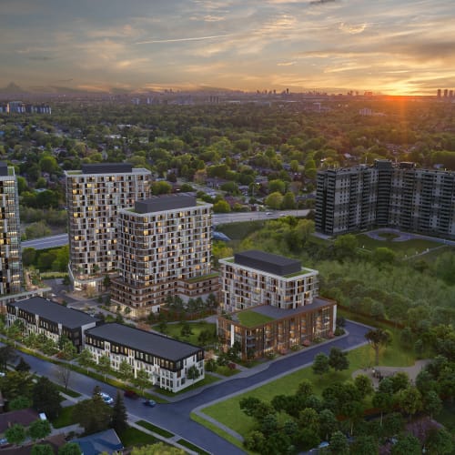
Aerial renderings have long been a staple in showcasing large-scale projects. By providing a bird's-eye view, they allow developers, investors, and potential buyers to grasp the full scope of a development, including its layout, surrounding environment, and connectivity to infrastructure. Traditional methods of capturing aerial views often involve satellite imagery or manned aircraft photography, both of which come with limitations in terms of resolution, flexibility, and cost.
In large developments, especially those spread over extensive geographical areas or consisting of multiple phases, static aerial images may fail to convey the dynamic nature of the project. This is where drone integration steps in, offering a versatile and cost-effective solution to capture high-resolution footage that can be seamlessly combined with architectural renderings.
The Emergence of Drone Technology in Real Estate
Drones, or unmanned aerial vehicles (UAVs), have revolutionized various industries, and real estate is no exception. The adoption of drone technology in real estate marketing and development has surged due to several key advantages:
- High-Quality Imaging: Modern drones are equipped with advanced cameras capable of capturing ultra-high-definition videos and images, providing crystal-clear visuals.
- Flexibility and Accessibility: Drones can navigate complex terrains and reach altitudes that may be challenging or impossible for manned aircraft, offering unique angles and perspectives.
- Cost-Effectiveness: Drones offer a more affordable alternative without compromising on quality than hiring helicopters or planes for aerial photography.
- Real-Time Data Collection: Drones can quickly gather data, allowing for timely updates and adjustments to project plans.
Combining Drone Footage with Architectural Renderings
Integrating drone footage with architectural renderings is a game-changer for visualizing large developments. This synergy works here:
Capturing the Real Environment
Drone footage provides a realistic context by capturing the actual terrain, vegetation, existing structures, and infrastructure surrounding the development site. When this real-world imagery is combined with 3D architectural renderings, it creates a hyper-realistic visualization that situates the proposed development within its genuine environment.
Enhancing Accuracy and Detail
Integrating drone data ensures that the renderings align precisely with the site's topography. This accuracy is crucial for identifying potential challenges related to land elevation, water bodies, and other natural features that could impact the development.
Dynamic Presentations
By overlaying 3D models onto drone videos, developers can create dynamic presentations that showcase how a project will look from various angles and during different times of the day. This interactive approach is far more engaging than static images, capturing the attention of stakeholders more effectively.
Phased Development Visualization
For multi-phase projects, drone footage can be periodically updated to reflect the progression of construction. When combined with renderings of upcoming phases, stakeholders gain a comprehensive view of the project's evolution over time.
Unique Perspectives Offered by Drone-Integrated Renderings
Immersive Experiences
Drone-integrated renderings offer immersive experiences that static images cannot match. For instance, a fly-through video can simulate a journey over and around the development, providing a virtual tour that highlights key features and amenities.
Contextual Awareness
Understanding how a development fits within its broader context is vital. Drone footage captures the surrounding neighborhoods, access roads, public transportation links, and natural landscapes. When combined with renderings, it offers a holistic view that aids in assessing the project's viability and appeal.
Stakeholder Engagement
Investors, regulatory bodies, and community members are more likely to engage with and support a project when they can visualize its impact. Drone-integrated renderings communicate complex information in an accessible format, fostering transparency and trust.
Benefits to Stakeholders
Developers
- Improved Planning: Accurate visuals help refine design elements, optimize layouts, and anticipate construction challenges.
- Marketing Advantage: High-quality visuals differentiate the project in a competitive market, attracting potential buyers and tenants.
Investors
- Informed Decision-Making: Detailed visuals provide clarity on the project's scope and potential return on investment.
- Risk Mitigation: Understanding the physical context helps in identifying potential risks associated with the site's location.
Regulators and Planners
- Compliance Assurance: Visuals aid in assessing whether the project adheres to zoning laws, environmental regulations, and community standards.
- Facilitated Approvals: Clear representations can expedite the approval process by addressing concerns proactively.
Community and Buyers
- Visualization of Impact: Residents can see how the development will affect their community, leading to constructive feedback.
- Enhanced Understanding: Potential buyers can visualize their future homes and surroundings, aiding in the sales process.
Challenges and Considerations
While the integration of drone footage and renderings offers numerous benefits, several challenges need to be addressed:
Technical Challenges
- Data Integration: Merging drone footage with 3D renderings requires sophisticated software and skilled professionals to ensure seamless integration.
- File Sizes: High-resolution images and videos can result in large file sizes, necessitating robust data storage and processing capabilities.
Regulatory and Privacy Concerns
- Airspace Regulations: Operators must comply with aviation laws, which may restrict drone flights in certain areas or at specific altitudes.
- Privacy Issues: Capturing images of private property or individuals without consent can lead to legal complications.
Cost Considerations
- Initial Investment: High-quality drones and software can be expensive, although they may offer cost savings in the long run.
- Professional Expertise: Hiring skilled operators and visualization experts adds to the project cost but is essential for optimal results.
Future Trends
Advancements in Drone Technology
- Enhanced Autonomy: Drones are becoming more autonomous, reducing the need for manual operation and allowing for more complex flight patterns.
- Improved Sensors: The integration of LiDAR and thermal imaging can provide additional data layers for more detailed renderings.
Integration with Virtual Reality (VR) and Augmented Reality (AR)
- VR Experiences: Combining drone footage with VR can create fully immersive environments for stakeholders to explore.
- AR Applications: On-site AR can overlay digital models onto the physical environment, assisting in construction and planning.
Real-Time Data Streaming
- Live Updates: Real-time drone data can be streamed to stakeholders, providing up-to-the-minute insights into project progress.
Conclusion
The integration of drone footage with architectural renderings represents a significant advancement in how large developments are visualized and communicated. This approach offers unique perspectives that enhance understanding, engagement, and decision-making for all stakeholders involved. By capturing the real-world context and combining it with detailed renderings, developers can present a comprehensive and compelling vision of their projects.
As drone technology continues to evolve, we can expect even more innovative applications in real estate development. Embracing these tools not only provides a competitive edge but also contributes to more efficient, transparent, and successful project outcomes. Developers who leverage drone-integrated aerial renderings position themselves at the forefront of industry innovation, setting new standards for how large-scale projects are planned, marketed, and realized.
References
- Federal Aviation Administration (FAA) Regulations on Drone Operations
- Emerging Trends in Real Estate® 2023
- The Impact of Drone Technology in Real Estate Marketing
- Integrating 3D Models with Drone Imagery
Note: Ensure compliance with local regulations and privacy laws when operating drones and using aerial footage for commercial purposes.